קובץ:Flying Through a Crack in the Ice (6795048198).jpg
Flying_Through_a_Crack_in_the_Ice_(6795048198).jpg (720 × 480 פיקסלים, גודל הקובץ: 126 ק"ב, סוג MIME: image/jpeg)
תקציר
| תיאור |
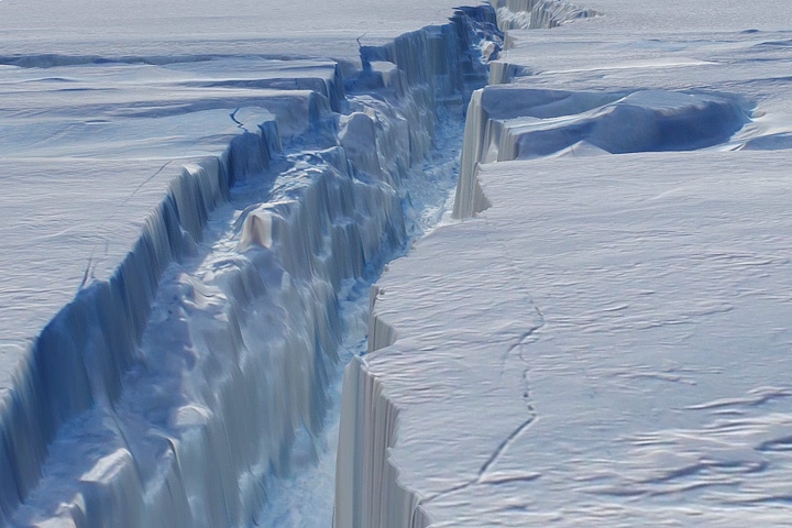
NASA image acquired October 26, 2011 In October 2011, researchers flying in NASA’s Operation IceBridge campaign made the first-ever detailed, airborne measurements of a major iceberg calving event while it was in progress. Four months later, the IceBridge team has mapped the crack in Antarctica’s Pine Island Glacier in a way that allows glaciologists and the rest of us to fly through the icy canyon. The above image is a still frame captured from a three-dimensional, virtual flight through the new rift in the Pine Island Glacier. (A high-definition version of the movie can be seen here www.flickr.com/photos/gsfc/6941158533 ) The animation was created by draping aerial photographs from the Digital Mapping System—a still camera with very precise geolocation ability—over data from the Airborne Topographic Mapper—a scanning laser altimeter that measures changes in the surface elevation of the ice. Both instruments were flown on NASA's DC-8 research airplane, and the data was collected on October 26, 2011. The crack formed in the ice shelf that extends from one of West Antarctica’s fastest-moving glaciers. The path of the crack in this animation stretches roughly 18 miles (30 kilometers) in length (the actual crack is much longer), with an average width of 240 feet (about 80 meters); it was 820 feet (250 meters) at its widest. The canyon ranged from 165 to 190 feet deep (50 to 60 meters), with the floor being roughly at the water line of the Amundsen Sea. Radar measurements suggested the ice shelf is about 1,640 feet (500 meters) feet thick, with only 165 to 190 feet of that floating above water and the rest submerged. Scientists have been waiting for the crack to propagate through the rest of the ice shelf and release an iceberg, which they estimate could span 300 to 350 square miles (up to 900 square kilometers). If it does not split off soon, however, the sea ice that forms with the onset of southern winter might keep the ice chunk trapped against the coast for a while. Pine Island Glacier last calved significant icebergs in 2007 and 2001, and some scientists speculated that it was primed to calve again. But until the IceBridge flight on October 14, 2011, no one had seen any evidence of the ice shelf beginning to break apart. Since then, a more detailed look back at satellite imagery seems to show the first signs of the crack in early October. Animation by the NASA IceBridge team. Caption by Mike Carlowicz, with reporting from Patrick Lynch and Jefferson Beck. Instrument: Aircraft Sensors Credit: NASA Earth Observatory NASA Goddard Space Flight Center enables NASA’s mission through four scientific endeavors: Earth Science, Heliophysics, Solar System Exploration, and Astrophysics. Goddard plays a leading role in NASA’s accomplishments by contributing compelling scientific knowledge to advance the Agency’s mission. Follow us on Twitter Like us on Facebook Find us on Instagram |
| תאריך יצירה | |
| מקור | Flying Through a Crack in the Ice |
| יוצר | NASA Goddard Space Flight Center from Greenbelt, MD, USA |
| מיקום המצלמה | | תמונה זו ותמונות נוספות במיקום: OpenStreetMap |
|---|
.jpg¶ms=-78.384855_N_0008.203117_E_globe:Earth_type:camera_source:Flickr_&language=he)
רישיון
- יש לך חופש:
- לשתף – להעתיק, להפיץ ולהעביר את העבודה
- לערבב בין עבודות – להתאים את העבודה
- תחת התנאים הבאים:
- ייחוס – יש לתת ייחוס הולם, לתת קישור לרישיון, ולציין אם נעשו שינויים. אפשר לעשות את זה בכל צורה סבירה, אבל לא בשום צורה שמשתמע ממנה שמעניק הרישיון תומך בך או בשימוש שלך.
| This image was originally posted to Flickr by NASA Goddard Photo and Video at https://flickr.com/photos/24662369@N07/6795048198. It was reviewed on 17 בספטמבר 2016 by FlickreviewR and was confirmed to be licensed under the terms of the cc-by-2.0. |
| קובץ זה נמצא ברשות הציבור מכיוון שהוא נוצר על ידי נאס"א. מדיניות זכויות היוצרים של נאס"א קובעת ש"חומרים של NASA אינם מוגנים בזכויות יוצרים אלא אם צוין אחרת". (דף מדיניות זכויות היוצרים ב-NASA או מדיניות שימוש בתמונות ב-JPL). | ||
 |
אזהרות:
|
היסטוריית הקובץ
ניתן ללחוץ על תאריך/שעה כדי לראות את הקובץ כפי שנראה באותו זמן.
| תאריך/שעה | תמונה ממוזערת | ממדים | משתמש | הערה | |
|---|---|---|---|---|---|
| נוכחית | 23:50, 17 בספטמבר 2016 | | 480 × 720 (126 ק"ב) | wikimediacommons>Vanished Account Byeznhpyxeuztibuo | Transferred from Flickr via Flickr2Commons |
שימוש בקובץ
הדף הבא משתמש בקובץ הזה:
.jpg)